High risk of tornadoes, powerful winds, hail and flash flooding for central US
The risk to lives and property has increased over portions of the Great Plains as severe weather and the likelihood of tornadoes peaks into this weekend, AccuWeather meteorologists warn. In addition to the likelihood of tornadoes, many of the storms will bring damaging winds and large hail, as well as flash flooding.
In the first volley of severe weather during the multiday outbreak, dozens of severe thunderstorms erupted from Wyoming and South Dakota to Texas and Arkansas Thursday afternoon and night with a few of the storms producing tornadoes and hail to the size of baseballs.
 |
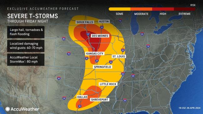
Well ahead of the prime days of severe weather, AccuWeather meteorologists issued high-risk zones for severe weather into Saturday night. These zones could not only be affected by a few tornadoes, but some of the storms could evolve into strong and possibly long-track twisters in portions of well-traveled interstates 29, 35, and 44 over the central and southern Plains.
"There could be more than a dozen tornadoes spawned into Friday night alone," AccuWeather Chief On-Air Meteorologist Bernie Rayno said. "Into Friday night, the areas most likely to be strewn with intense, discrete thunderstorms -- the type that often produces strong tornadoes -- extends from northeastern Kansas and northwestern Missouri to southeastern Nebraska and southern and central Iowa."
 |
Major metro areas that are very close to or within the high-risk area into Friday night include Kansas City, Missouri; Omaha, Nebraska; and Des Moines, Iowa.
Another pocket where a moderate risk of severe weather risks extends from northeastern Texas to southeastern Oklahoma and southwestern Arkansas.
The AccuWeather Local StormMax™ straight-line wind gust is 80 mph into Friday night and is stronger than that of the minimum threshold for a hurricane (74 mph).
The overall risk of severe weather into Friday night extends for at least 800 miles from southeastern South Dakota and southern Minnesota to northeastern Texas, home to 35 million people.
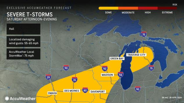
On Saturday afternoon and Saturday night, the storm system responsible for Friday's severe weather will race toward Ontario, Canada. Enough energy and fuel may remain in the atmosphere to set off locally severe thunderstorms packing high winds, hail and torrential downpours from Iowa to the northern part of Michigan's Lower Peninsula.
 |
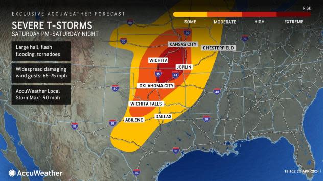
Farther to the south, the high risk of severe weather will extend from central and eastern Kansas and southwestern Missouri to central and northeastern Oklahoma. The high risk of severe thunderstorms on Saturday includes the metro areas of Oklahoma City and Tulsa, Oklahoma, as well as Wichita, Kansas.
"This high-risk zone on Saturday afternoon and evening will be prime for powerful storms with damaging hail and high winds, as well as a few tornadoes," Rayno said. On Saturday, the AccuWeather Local StormMax™ straight-line wind gust is 90 mph. Gusts this strong outside of tornadoes can knock over utility poles and large trees and cause significant property damage.
 |
More than 55 million people will be in the zone where severe weather may occur from Saturday to Saturday night.
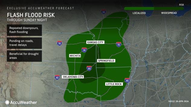
"There is also a substantial risk of dangerous flash flooding on Saturday, especially from eastern Kansas, western Missouri, eastern Oklahoma and western Arkansas," Rayno added.
 |
The flash flood risk into Sunday night extends over a large portion of the central and southern Plains states, including all of the Ozark Mountains. People planning weekend camping trips are urged to avoid setting up in flood-prone areas along small streams. Rushing high water could block secondary access roads to and from the campsites.
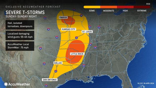
On Sunday, the severe weather zone will extend for more than 800 miles from eastern Nebraska and Iowa to San Antonio. AccuWeather meteorologists have raised the severe weather threat to a moderate level on Sunday for much of Arkansas and parts of northeastern Texas, eastern Oklahoma and southern Missouri. A second area with a moderate risk will include parts of southeastern Nebraska, southwestern Iowa and northwestern Missouri.
 |
The severe weather threats Sunday will range from high winds and large hail to tornadoes and flash flooding, with more than 35 million people at risk.
People in the severe weather threat zones each day and night are encouraged to pay attention to the weather, take alerts and warnings seriously and have a plan of action in place in case violent conditions become imminent. A method to receive audible alerts when sleeping is strongly advised.
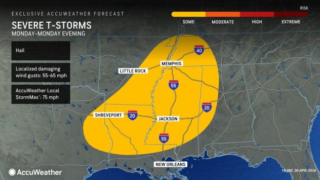
There is the potential for severe weather to continue into Monday in parts of the South Central states. Heavy, gusty thunderstorms will likely extend from northeastern Texas to Louisiana, central and northern Mississipi, western Alabama, southern Arkansas and western Tennessee. Within this zone, some storms will carry the risk of damaging wind gusts and hail. It is possible the storms could reach all the way to the northwestern and central Gulf coast.
 |
A separate pocket of heavy, gusty, and perhaps locally severe thunderstorms may also develop in parts of the Northeast from Monday to Tuesday.
Want next-level safety, ad-free? Unlock advanced, hyperlocal severe weather alerts when you subscribe to Premium+ on the AccuWeather app. AccuWeather Alerts™ are prompted by our expert meteorologists who monitor and analyze dangerous weather risks 24/7 to keep you and your family safer

