
Hurricane Lee downgraded to Category 3 storm as US impacts still ‘too soon to know’: Live

Hurricane Lee exploded into a powerful Category 5 storm within 24 hours as it whirled across the open Atlanta Ocean but has downgraded to a Category 3, though forecasted predict could gain strength over the weekend and into next week.
“Confidence in the intensity forecast is low at the moment, although it is likely that Lee will remain a dangerous hurricane for at least the next [five] days,” according to the National Hurricane Center.
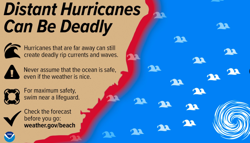
It remains “too soon to know” what its potential impacts “if any” along the US Atlantic seaboard could look like, though “dangerous surf and rip currents are expected” on Sunday and Monday and could “worsen” in the coming week, the center announced.
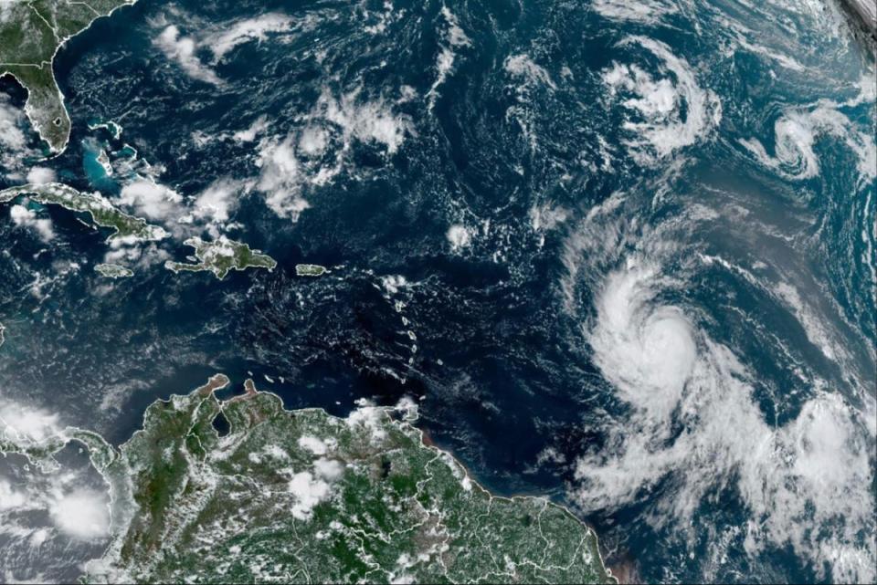
Lee was roughly 400 miles east-northeast of the northern Leeward Islands as of Saturday, with maximum sustained winds of 115 mph.
The storm is expected to pass north of Puerto Rico, the Virgin Islands and the northern Leeward Islands, according to forecasters, but life-threatening surf and rip conditions generated by the hurricane could impact the British and US Virgin Islands, Puerto Rico, Hispaniola, the Turks and Caicos Islands, the Bahamas and Bermuda.
Key Points
Hurricane Lee rapidly intensifies to ‘extremely dangerous’ Category 5 storm
Here’s how quickly the storm picked up speed
Where is the storm currently and where will it head?
Spaghetti models show Hurricane Lee’s potential paths
Latest Lee advisory: Hurricane expected to pass north of Leeward Islands while generating dangerous waves over weekend
22:10 , Alex Woodward
Hurricane Lee, still a Category 3 storm, is expected to pass “pass well to the north of the northern Leeward Islands, the Virgin Islands, and Puerto Rico into early next week,” according to an afternoon advisory from the National Hurricane Center.
Maximum sustained winds are near 115 mph with higher gusts, and gradual “restrengthening” is possible during the next couple of days, the center predicts.
Swells generated by Lee are affecting portions of the Lesser Antilles and will spread westward to the British and US Virgin Islands, Puerto Rico, Hispaniola, the Turks and Caicos Islands, the Bahamas, and Bermuda through the weekend. Those swells are “likely to cause life-threatening surf and rip current conditions,” according to the report.
“Dangerous surf and rip currents” are also expected along the US East Coast on Sunday and Monday and then worsen through the week.
Hurricane #Lee Advisory 18: Lee to Pass Well North of the Leeward Islands During the Next Day Or So. Hazardous Beach Conditions Expected to Develop Around the Western Atlantic Through Next Week. https://t.co/tW4KeGe9uJ
— National Hurricane Center (@NHC_Atlantic) September 9, 2023
Too soon to tell but too soon to rule out significant impacts, forecasters say
22:00 , Alex Woodward
Hurricane Lee was significantly disrupted by wind shear within the 24 hours after it accelerated into a Category 5 hurricane, as it then degraded into a Category 4 then Category 3 into Saturday morning.
Models are suggesting that the shear will subside by Sunday morning, which could allow Lee to gain more strength as it continues to track east, according to Levi Cowan with Joint Typhoon Warning Center.
“Regardless of Lee’s exact intensity, it will be a major hurricane tracking north of the Caribbean and then turning northward over the western Atlantic over the next week,” he said.
“It remains too soon to rule out impacts from Lee” as models predict it could track forwards Bermuda, Canada and the northeastern US, he added.
Hurricane #Lee has been disrupted significantly by some mid-level wind shear in the past 24 hours, with max winds down to 115 mph after being as high as 160 mph at one point. Models suggest that the shear will subside by Sunday morning, probably allowing Lee to regain strength.… pic.twitter.com/vOikNUrYQs
— Dr. Levi Cowan (@TropicalTidbits) September 9, 2023
Lee shattered ‘rapid intensification’ standards, a warning of future storms amid growing climate crisis
21:02 , Alex Woodward
Hurricane Lee’s acceleration from an 80 mph Cat 1 to a Cat 5 with 160 mph winds within 24 hours has surpassed the standards meteorologists typically associate with “rapid intensification,” or when winds increase by 35 mph within that same time period.
It not only makes Lee the fastest-intensifying Atlantic storm on record, it has set a new threshold that scientists see as a potential harbinger for what’s to come as the climate crisis accelerates.
“This one increased by 80 mph,” Marshall Shepherd, director of the University of Georgia’s Atmospheric Sciences Program and a past president of the American Meteorological Society told the Associated Press. “I can’t emphasize this enough – we used to have this metric of 35 mph, and here’s a storm that did twice that amount and we’re seeing that happen more frequently.”
Lee and Margot could mingle in the Atlantic
18:57 , Alex Woodward
Newly formed Tropical Storm Margot is expected to grow into a hurricane next week, raising the possibility that Hurricane Lee’s path could be changed, though it is still far too soon to project whether the two major storms could get close to one another in the Atlantic.
Such a phenomenon, when two storms rotate around each other and spin in the same direction, is called the Fujiwhara effect. The National Weather Service describes it as “an intense dance around their common center.”
That could then push them both around the Atlantic and alter their paths.
The phenomenon occured with hurricanes Hilary and Irwin in the East Pacific in 2017.
Watch Lee intensify from Category 1 to Category 5 storm
18:04 , Alex Woodward
Lee marked the first Category 5 hurricane of this year’s Atlantic season when it rapidly grew from a Category 1 within 24 hours this week. There have been seven other Cat 5 storms from the Atlantic since 2016, with one – Michael – making landfall in the US in 2018.
Within thouse 24 hours, Hurricane Lee intensified from an 80 mph Cat 1 to a Cat 5 with 160 mph winds, likely making it the fastest-intensifying Atlantic storm on record.
Lee has since diminished to a Cat 3 storm and is expected to maintain its strength over the weekend.
#Lee's life story, Chapter 1: From African easterly wave to sudden extreme intensification into a Category 5 #hurricane (wait for it) pic.twitter.com/1EWakTRkBe
— Stu Ostro (@StuOstro) September 8, 2023
Lee ‘maintaining strength’ but ‘little change expected’ on Saturday
16:25 , Alex Woodward
Hurricane Lee is “maintaing strength” as a recently downgraded Category 3 storm as it moves across the Atlanta Ocean with maximum sustained winds of 115 mph with higher gusts, according to the latest advisory from the National Hurricane Center.
“Little change in strength is expected today, but gradual restrengthening is forecast to occur on Sunday and Monday,” according to the advisory.
11AM AST Sep 9: @NOAA_HurrHunter & @53rdWRS find #Lee maintaining strength this morning. Hazardous beach conditions are expected around the western Atlantic through next week. Visit https://t.co/tW4KeGe9uJ for the latest information pic.twitter.com/xXiy8NY8Ux
— National Hurricane Center (@NHC_Atlantic) September 9, 2023
Lee is in rare company during an already-historic storm year
15:35 , Alex Woodward
For the first time on record, Category 5 storms have formed in every tropical ocean basin within one year.
Lee, which has since downgraded to a Category 3 as it tracks along open Atlantic Ocean, accelerated from Category 1 strength into a Category 5 this week.
“I think it’s reasonable to hypothesize that the abnormally warm ocean temperatures around the world made this more likely to happen,” University of Miami, hurricane expert Brian McNoldy told The Washington Post. “Gives everything a boost.”
Saturday, Sept 9th 5 AM AST Key Messages for Hurricane #Lee: It is too soon to know what level of impacts, if any, Lee might have along the U.S. East Coast, Atlantic Canada, or Bermuda late next week. Continue to monitor forecasts at https://t.co/tW4KeGe9uJ for the latest. pic.twitter.com/2106DvFQFh
— National Hurricane Center (@NHC_Atlantic) September 9, 2023
‘Way too soon’ to chart US impacts, if any, but Lee could strengthen as it moves across open ocean
14:30 , Alex Woodward
Hurricane Lee ramped up to a Category 5 storm within 24 hours this week, but it has been downgraded to a Category 3 and will likely lose strength over the course of the day as it struggles with wind shear.
The National Hurricane Center continues to stress it is still “way too soon” to know what impacts, if any, the storm could have along the East Coast of the US, and the storm could gain strength as it continues to move with sustained winds at 115 mph as of Saturday morning.
Dangerous and life-threatening rip currents are affecting parts of the Leeward Islands, according to NHC. Those conditions are expected to impact parts of Puerto Rico, Hispaniola, the Turks and Caicos Islands, the Bahamas and Bermuda over the weekend.
Saturday, Sept 9th 5 AM AST Key Messages for Hurricane #Lee: It is too soon to know what level of impacts, if any, Lee might have along the U.S. East Coast, Atlantic Canada, or Bermuda late next week. Continue to monitor forecasts at https://t.co/tW4KeGe9uJ for the latest. pic.twitter.com/2106DvFQFh
— National Hurricane Center (@NHC_Atlantic) September 9, 2023
Will Hurricane Lee reach New York?
11:06 , Louise Boyle
Some forecast models suggest that Hurricane Lee could graze the US East Coast - but the jury is still out.
“Regardless, dangerous surf and rip currents are expected along most of the US East Coast beginning Sunday,” the National Hurricane Center warned.
Joe Sommerlad reports
Will Hurricane Lee reach New York?
Watch: Inside the eye of Hurricane Lee
10:07 , Louise Boyle
Lee gains elite status
09:03 , Louise Boyle
Lee is expected to keep strengthening and reach winds of up to 180mph (290kph).
Only seven Atlantic hurricanes have had winds of that magnitude since 1966, according to Colorado State University hurricane researcher Phil Klotzbach.
Among those was Hurricane Dorian, which pummeled the northern Bahamas in 2019 as a Category 5 storm, hovering over small islands for some two days.
The Associated Press
Lee gains elite status
05:05 , Louise Boyle
Lee is expected to keep strengthening and reach winds of up to 180mph (290kph).
Only seven Atlantic hurricanes have had winds of that magnitude since 1966, according to Colorado State University hurricane researcher Phil Klotzbach.
Among those was Hurricane Dorian, which pummeled the northern Bahamas in 2019 as a Category 5 storm, hovering over small islands for some two days.
The Associated Press
Watch: Inside the eye of Hurricane Lee
04:04 , Louise Boyle
Hurricane Lee powers through Caribbean as forecasters warn ‘too soon to know’ of US impact next week
01:01 , Graeme Massie
‘We will see waves between 10 and 15 feet, so we don’t want anyone on the beaches’.

Hurricane Lee powers through Caribbean as ‘too soon to know’ on US impacts next week
Ocean warnings
Saturday 9 September 2023 00:03 , Louise Boyle
The National Hurricane Center said that dangerous surf and deadly rip currents will likely hit the northern Leeward Islands later Friday from Hurricane Lee.
They would spread to Puerto Rico, Hispaniola, the Turks and Caicos, the Bahamas and Bermuda over the weekend.
“We will see waves between 10 and 15 feet (3 and 5 meters), so we don’t want anyone on the beaches,” said Ernesto Morales with the National Weather Service in San Juan, Puerto Rico.
The National Hurricane Center said dangerous surf and rip currents were forecast for most of the US East Coast starting Sunday. (AP)
Will Hurricane Lee reach New York?
Friday 8 September 2023 23:02 , Louise Boyle
Some forecast models suggest that Hurricane Lee could graze the US East Coast - but the jury is still out.
“Regardless, dangerous surf and rip currents are expected along most of the US East Coast beginning Sunday,” the National Hurricane Center warned.
Joe Sommerlad reports
Will Hurricane Lee reach New York?
FEMA prepared for worst-case scenario in Puerto Rico in response to Hurricane Lee
Friday 8 September 2023 22:00 , Graig Graziosi
Hurricane Lee strengthened to a Category 5 storm on Thursday evening. The same day, Joe Biden was briefed by the Federal Emergecy Management Agency about its preparations in the event the storm’s force caused disruptions in Puerto Rico and the US Virgin Islands.
FEMA said it had prepared approximately 4.5 million meals and nearly 8.9 million liters of water for Puerto Rico. Another 250,000 meals and more than 600,000 liters of water were made available for the US Virgin Islands.
The agency also deployed rapid response teams to both of the US territories in the event the storm turned and threatened the islands.
Thankfully, Hurricane Lee did not make landfall on any of the islands and is continuing north along the US east coast.
‘No reason’ for east coast US residents to be fearful of Hurricane Lee
Friday 8 September 2023 21:40 , Graig Graziosi
Jamie Rhome, the director of the National Hurricane Centre, said that right now there is “no reason” for east coast US residents to fear Hurricane Lee’s trajectory outside of rip current risks.
“There’s absolutely no indication in front of us that this is going to be a huge threat to Florida, other than it’s going to be a huge rip current risk,” Mr Rhome told USA Today. “Right now, save the rip current risk, which is extreme, there’s no reason for people on the East Coast to be fearful. We need them to be informed and aware and check back for details but right now there’s no reason other than rip currents for people to be fearful.”
Hurricane Lee underwent rapid intensification, strengthening from a Category 2 to Category 4 storm in just six hours, according to the National Hurricane Centre.
The storm became a Category 5 hurricane on Thursday night, but has since weakened to a Category 4.
Tracking Hurricane Lee’s evolution
Friday 8 September 2023 21:10 , Graig Graziosi
Tropical Storm Lee formed in the Atlantic Ocean and under went rapid intensification into an “extremely dangerous” hurricane, eventually reaching Category 5 before it slowed to Category 4 on Friday morning.
Tropical Storm Lee was announced by the National Hurricane Center (NHC) at 5pm (eastern time) on Tuesday.
Its wind speeds picked up on Tuesday afternoon and was forecast to become a major hurricane.
“The depression is forecast to become a major hurricane by this weekend and could bring impacts to the Leeward Islands by that time,” NHC reported at the time.
READ MORE:

Tropical Storm Lee expected to become ‘extremely dangerous’ hurricane by weekend
Hurricane Lee: What is the path of the monster storm?
Friday 8 September 2023 20:50 , Graig Graziosi
Hurricane Lee reached Category 5 on Friday, after “rapidly strengthening” as it stirred through the Caribbean, the US National Hurricane Center reported on Thursday.
Hurricane Lee began to strengthen over the very warm waters of the Atlantic, growing from a tropical storm into a Category 1 hurricane on Wednesday and by late Thursday night, it had grown to Category 5, with maximum sustained winds of 160mph.
By Friday morning, forecasters said Lee could become a “monster 180mph” storm.
The storm reached its peak Thursday night and became to be a vicious hurricane over the southwestern Atlantic before weakening to a Category 4 on Friday morning.
READ MORE:
Tracking Hurricane Lee: What is the path of the monster storm?
Will Hurricane Lee reach New York?
Friday 8 September 2023 20:30 , Graig Graziosi
Hurricane Lee, currently barreling westwards through the Atlantic towards the Caribbean islands, rapidly intensified into a Category 5 storm on Thursday night and it is feared the storm could soon work up to wind speeds of 180mph.
It is expected to pass well to the north of the northern Leeward Islands, the Virgin Islands and Puerto Rico over the weekend and into early next week, according to forecasters.
After that, however, its path is less clear cut, with different models reaching different verdicts as to precisely how close it could pass along the US East Coast as it steers northwards, already inspiring some premature and slightly hysterical tabloid headlines.
More credibly, CBS has warned that Hurricane Lee’s path “might” bring it to New York City and the Tri-State Area, reporting that initial forecasts suggested “a landfall in the Mid-Atlantic region, and then riding up the coastline towards New York” before drifting out to sea.
READ MORE:
Will Hurricane Lee reach New York?
National Hurricane Centre warns of surf, rip currents in the Caribbean, US east coast
Friday 8 September 2023 20:07 , Graig Graziosi
The National Hurricane Centre has warned that Hurricane Lee — now a Category 4 storm after it strengthened into a Category 5 storm on Thursday — could produce high surf and life-threatening rip currents in the northeastern Caribbean on Friday and throughout the weekend.
The centre also said that rough surf and hazardous ocean conditions were likely along much of the US east coast by Sunday evening.
Hurricane Lee is continuing to churn in the Atlantic basin, with spaghetti models predicting a northern track, with a possible threat to New England and Canada’s east coast.
Hurricane Lee still ‘very powerful’ despite weakening
Friday 8 September 2023 19:30 , Graig Graziosi
The National Hurricane Centre said that Hurricane Lee is still a “very powerful” storm despite weakening from a Category 5 to a Category 4 storm between Thursday night and Friday morning.
“Although Lee’s current intensity is lower than the overnight peak, the hurricane remains very powerful,” the centre said.
Hurricane Lee is expected to remain a strong storm into early next week as it continues north through the Atlantic. It is still unclear what impact it might have on the US, but some spaghetti models show the storm on a course for New England and Canada’s east coast.
Half of world’s population suffered under climate crisis-fuelled extreme heat this year
Friday 8 September 2023 19:10 , Louise Boyle
Half the world was exposed to at least 30 days of extreme heat driven by the climate crisis between June and August, a new study has found.
Over 3.8 billion people suffered extreme temperatures for more than a month, while “nearly every living human” – around 98 per cent of the world – was exposed to extreme heat at least once between June and August 2023, an analysis released on Thursday by the nonprofit Climate Central showed.
The longest duration of extreme temperatures, approximately three months, was experienced by at least 1.5 billion people, the study says.
“Virtually no one on Earth escaped the influence of global warming during the past three months,” Dr Andrew Pershing, vice president for science at Climate Central, said.
Stuti Mishra reports

Half of world’s population suffered under extreme heat this summer, study says
‘Hurricane hunter' pilot captures lightning show inside Hurricane Lee
Friday 8 September 2023 19:00 , Graig Graziosi
A user on X/Twitter recorded video from the inside of Hurricane Lee, capturing a stunning lightning storm inside the churning storm.
Hurricane Lee underwent rapid intensification yesterday, strengthening from a Category 2 to a Category 4 storm in just six hours.
The storm reached Category 5 on Thursday night before weakening back to a Category 4 on Friday.
Nice lighting show in the eye of #HurricaneLee this morning pic.twitter.com/F3Spj54syS
— FlyAnon (@FlynonymousWX) September 8, 2023
Ocean warnings
Friday 8 September 2023 18:38 , Louise Boyle
The National Hurricane Center said that dangerous surf and deadly rip currents will likely hit the northern Leeward Islands later Friday from Hurricane Lee.
They would spread to Puerto Rico, Hispaniola, the Turks and Caicos, the Bahamas and Bermuda over the weekend.
“We will see waves between 10 and 15 feet (3 and 5 meters), so we don’t want anyone on the beaches,” said Ernesto Morales with the National Weather Service in San Juan, Puerto Rico.
The National Hurricane Center said dangerous surf and rip currents were forecast for most of the US East Coast starting Sunday. (AP)
Will Hurricane Lee reach New York?
Friday 8 September 2023 18:05 , Louise Boyle
Some forecast models suggest that Hurricane Lee could graze the US East Coast - but the jury is still out.
“Regardless, dangerous surf and rip currents are expected along most of the US East Coast beginning Sunday,” the National Hurricane Center warned.
Joe Sommerlad reports
Will Hurricane Lee reach New York?
Watch: Inside the eye of Hurricane Lee
Friday 8 September 2023 17:33 , Louise Boyle
Lee gains elite status
Friday 8 September 2023 17:10 , Louise Boyle
Lee is expected to keep strengthening and reach winds of up to 180mph (290kph).
Only seven Atlantic hurricanes have had winds of that magnitude since 1966, according to Colorado State University hurricane researcher Phil Klotzbach.
Among those was Hurricane Dorian, which pummeled the northern Bahamas in 2019 as a Category 5 storm, hovering over small islands for some two days.
The Associated Press
‘Distant but deadly'
Friday 8 September 2023 16:40 , Louise Boyle
US forecasters had this warning for Americans on Friday as Category 5 Hurricane Lee roars through the Caribbean.
“Distant hurricanes can be deadly,” NOAA warned and said that beach-goers should be aware of rip currents and powerful waves.
Inside the eye of Hurricane Lee
Friday 8 September 2023 16:15 , Louise Boyle
The US Air Force Reserve’s “Hurricane Hunters” shared dramatic footage from inside Hurricane Lee on Thursday night.
The 403rd Wing Reserves posted on X, formerly Twitter, footage of the rotating thick clouds with lightning bursts.
“Here’s last night’s flight inside the eye of Cat 5 Hurricane Lee,” they wrote.
Here’s last night’s flight inside the eye of Cat 5 #hurricaneLee pic.twitter.com/I9Gmy4sHut
— Hurricane Hunters (@53rdWRS) September 8, 2023
Will Hurricane Lee make landfall?
Friday 8 September 2023 15:43 , Louise Boyle
The current forecasts show that Hurricane Lee is not expected to make landfall in the coming days - but that doesn’t rule out “life-threatening” impacts.
The storm is forecast to pass well to the north of the northern Leeward Islands, the Virgin Islands, and Puerto Rico over the weekend and into early next week.
However, “it is way too soon” to know what level of impacts, if any, Lee might have along the US East Coast, Atlantic Canada or Bermuda, late next week, according to the National Weather Service.
Watch: Hurricane Lee gathering strength in Caribbean waters
Friday 8 September 2023 15:27 , Louise Boyle
Waves up to 15 feet
Friday 8 September 2023 15:50 , Louise Boyle
The hurricane is not expected to make landfall, but meteorologists warned it would generate dangerous waves of up to 15 feet (5 meters) across the northern coast of Puerto Rico and other nearby islands from today.
While Lee is on a path that would take it a couple hundred miles northeast of the Caribbean, tropical storm conditions are not forecast for the region.
“Although the hurricane is incredibly powerful, its wind field is not particularly large,” the National Hurricane Center said.Associated Press
Florida residents share heartbreaking photos of Hurricane Idalia’s wrath
Friday 8 September 2023 14:50 , Louise Boyle
Just a week ago, the southern United States was dealing with the last major storm to barrel in from the ocean, its residents suffering the same anxieties and making the same last-ditch preparations that many Caribbean islanders will be readying now.
Hurricane Idalia smashed into Cuba, northern Florida, Georgia and the Carolinas before blowing itself out over the Atlantic and the photographs posted on social media by the people living in those states provide a fresh reminder, if any were needed, of the devastating impact of the climate crisis in action.
Can sharks help predict hurricanes?
Friday 8 September 2023 14:20 , Louise Boyle
As the climate crisis continues to deliver more and more extreme weather events and intensify hurricane season in North America, scientists are looking at new ways to gather information from the natural world to provide advanced warning of coming storms and avert disaster – and some believe sharks could play a key role.
Currently, meteorologists grounded on terra firma can predict a hurricane’s path up to five days in advance using costly satellite technology and atmospheric equipment.
But, by closely monitoring the behaviour of sharks, which can sense the shifts in barometric pressure that indicate a storm approaching through the pores in their snouts, even from as far away as 100 miles, that notice period could potentially be extended to as much as two weeks in advance, according to researchers.
5am update on Hurricane Lee
Friday 8 September 2023 13:50 , Louise Boyle
Hurricane Lee was declared a “powerful” Category 5 storm on Friday and is expected to maintain its intensity as it moves through the Caribbean with “life-threatening” conditions.
The system will bring “dangerous beach conditions” to Caribbean islands today, then dangerous surf and rip currents along most of the US East Coast from Sunday, the US National Hurricane Center (NHC) said in its 5am advisory.
Lee was located 630 miles (1015km) east of the northern Leeward Islands with sustained winds of 165mph (270km/h).
Fluctuations in intensity are likely over the next few days, but Lee is expected to remain a major hurricane through early next week, NHC reported.
The storm is not expected to make landfall and pass well to the north of the northern Leeward Islands, the Virgin Islands, and Puerto Rico over the weekend and into early next week.
‘No one wants this one’
Friday 8 September 2023 13:30 , Joe Sommerlad
Weather Twitter is (as usual) awash with dramatic GIFs of Hurricane Lee’s predicted progression this morning, as well as the usual deluge of alarming but unrelated flooding footage from around the world and earlier storm events.
But Lee does indeed appear to be a powerful beastie and warnings about it should be taken seriously once it does look like making landfall.
What a sight to see-
Cat 5 Hurricane Lee. This hurricane rapidly intensified yesterday faster than almost every other RI event in the books.
Models this morning still keep consistency in the forecast, which of course is a good thing for us.
No one wants this one… pic.twitter.com/PzpZhse26I— Eric Burris (@EricBurrisWESH) September 8, 2023
Here's how quickly Hurricane Lee intensified
Friday 8 September 2023 13:00 , Joe Sommerlad
Hurricane Lee is being termed “one of the fastest” if not the fastest-developing storm ever recorded in the Atlantic, as it went from Category 1 on Thursday morning to Category 5 by the day’s end.
The storm is expected to intensify further to reach wind speeds of 180mph by Friday morning.
Here’s how Lee’s rapid intensification played out:
Lee was a Category 1 storm with 80 mph winds at 5am ET on Thursday. Within 12 hours, its maximum sustained winds had increased to 130 mph, making it a Category 4 storm on the Saffir-Simpson intensity scale.
By 11pm ET, the storm’s maximum sustained winds were 160 mph, making it now a Category 5 hurricane.
The storm’s maximum sustained winds increased by just over 80 mph in 24 hours, according to the NHC. The escalation greatly exceeds the 35 mph increase needed to fit the definition of rapid intensification.
What is El Nino and why is it intensifying this year’s hurricanes?
Friday 8 September 2023 12:30 , Joe Sommerlad
The UN’s World Meteorological Organisation (WMO) has announced the return of the weather cycle El Nino, which could lead to record global temperatures this year.
After three years of the cooler La Nina pattern, which often lowers global temperatures slightly, the WMO announced on Tuesday that El Nino conditions were present and are expected to gradually strengthen into the winter.
The last significant El Nino event occurred in 2016, which has gone down as the warmest year the world has seen since records began.
Its recurrence in 2023, when global heating driven by man-made carbon emissions has only accelerated, threatens a “double whammy”, according to the WMO, which has warned there is a 90 per cent probability of it lasting to the year’s end.
That means the likelihood of extreme weather events that could prove life-threatening has also increased, prompting the organisation’s officials to caution world governments that they must be prepared.
Hurricanes are getting stronger. Here’s why
Friday 8 September 2023 12:00 , Stuti Mishra
As the global average temperature increases, largely due to the carbon emissions from burning fossil fuels, the ocean is taking a major hit.
The ocean has absorbed 90 per cent of warming in recent decades and all that extra heat is driving historically high water temperatures.
Warmer waters supercharge tropical cyclones with more heavy rainfall and storm surge as they come ashore.While the frequency of hurricanes of tropical storms is not increasing, the chance that they become stronger, more destructive systems has increased by about 8 per cent per decade in the past 40 years, according to climate scientists.
The proportion of Category 4 and 5 tropical cyclones is projected to increase around the world in the coming decades due to human-caused warming, according to the latest report from the UN’s Intergovernmental Panel on Climate Change (IPCC).
The Atlantic hurricane season, which runs from 1 June to 30 November, is forecast to be above average this year.
Latest forecast: Lee maintining its intensity as Margo strengthens
Friday 8 September 2023 11:45 , Joe Sommerlad
Here’s the latest from the National Hurricane Center, which says Hurricane Lee is expected to maintain its current intensity while Tropical Storm Margo is now expected to strengthen too.
The centre says it is “way too soon to know what level of impacts, if any, Lee might have along the US East Coast”.
5 am AST - Hurricane #Lee is a powerful category 5 hurricane. Here are the Key Messages. Visit https://t.co/tW4KeGe9uJ for details. pic.twitter.com/wERUw5oN5x
— National Hurricane Center (@NHC_Atlantic) September 8, 2023
Tropical Storm #Margot Advisory 4: Margot Forecast to Strengthen. https://t.co/tW4KeGe9uJ
— National Hurricane Center (@NHC_Atlantic) September 8, 2023
Meteorologist says eastern Canada, New Englanders are watching Hurricane Lee’s trajectory and hoping for an northeast swing
Friday 8 September 2023 11:00 , Stuti Mishra
John Morales, NBC6’s hurricane expert, said residents of Canada’s easternmost provinces and New England in the US are likely watching Hurricane Lee’s expected trajectory as it intensified to a Category 5 storm.
While Hurricane Lee is expected to miss landfall in the Caribbean and Florida, it may take a northward turn, which could bring its effects — like significant storm surges and high winds — to the northeastern portion of North America.
“Residents of Canada’s easternmost provinces, and even New Englanders in the US, are aware of Lee and hoping that a northbound track will be followed by another turn to the northeast, sparing them,” Mr Morales said in his analysis.
‘Above normal’
Friday 8 September 2023 10:15 , Stuti Mishra
The National Ocean and Atmospheric Administration warned in August that this year’s season would produce an above-normal number of storms. Between 14 to 21 named storms are forecast. Of those, six to 11 could become hurricanes, with two to five of them possibly becoming major hurricanes, the agency said.
Meanwhile, AccuWeather updated its forecast, predicting there would be three to five hurricanes Category 3 or stronger this season, compared with one to three in its previous analysis.
AP
How strong will Hurricane Lee become?
Friday 8 September 2023 09:30 , Stuti Mishra
Hurricane Lee is expected to continue intensifying into Friday and it could attain wind speeds of 180mph or more in the next 12 hours, making it one of the strongest storms in the Atlantic.
Hotter ocean waters this year are contributing to rapid intensification of storms this year, experts have said. Water temperatures in this part of the Atlantic Ocean were record warm in August driven by man-made climate crisis.
Hurricane Jova continues to churn in Pacific as Category 4 storm
Friday 8 September 2023 08:45 , Stuti Mishra
In the Pacific, Hurricane Jova churned through open waters far from Mexico's southwest coast as a Category 4 storm. It posed no threat to land.
It was located about 600miles (965km) southwest of the southern tip of Baja, California, and was moving west-northwest at 17mph (28kph) with winds up to 145mph (230kph). The storm was expected to start to weaken starting late on Thursday or early Friday.
Lightning strikes can be seen around Hurricane Jova's eye as it achieved category 5 status for a brief time last night. pic.twitter.com/vIKM6jDpgl
— CIRA (@CIRA_CSU) September 7, 2023
Another tropical storm, Margot, forms in the Atlantic
Friday 8 September 2023 08:03 , Stuti Mishra
While all eyes are on rapidly intensifying Hurricane Lee, another tropical storm has formed in the Atlantic, the National Hurricane Center reported.
Tropical Storm Margot is expected to become a hurricane over the weekend, the NHC said,
The storm was spotted about 355 miles west of The Cabo Verde Islands with maximum sustained winds of 40 mph. It was moving west-northwest at 16 mph.
Tropical Storm #Margot Advisory 3: Margot Moving West-Northwestward Across the Tropical Eastern Atlantic. https://t.co/tW4KeGe9uJ
— National Hurricane Center (@NHC_Atlantic) September 8, 2023

