
Severe thunderstorm warning lifted for Ottawa-Gatineau
Environment Canada has lifted a severe thunderstorm warning for Ottawa-Gatineau, although it continues to track powerful storms capable of brutal wind gusts and toonie-sized hail.
As of 7:30 p.m. ET, thunderstorm warnings were in place elsewhere in eastern Ontario and western Quebec, including such communities as:
Pembroke
Eganville
Petawawa
Maniwaki
Quyon
Wakefield
Chelsea
A severe thunderstorm watch remains in place for Ottawa-Gatineau as well as many surrounding communities including Kingston, Pembroke, Cornwall, Perth and Brockville.
In Ottawa, storms this evening could produce wind gusts of up to 90 km/h and toonie-sized hail.
Environment Canada had previously issued tornado warnings for the Barry's Bay and Deep River areas but those have been lifted.
There is currently no mention of a potential tornado for the nation's capital.
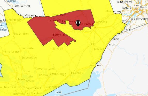
This map shows the extent of thunderstorm watches (yellow) and warnings (red) in place for the region as of 6:45 p.m. Wednesday. (Environment Canada)
Ottawa's main airport recorded 17.4 millimetres of rain in a few hours during Tuesday's storm, the greatest single-day volume in six weeks.
Wednesday's forecasted high temperature in Ottawa is 30 C, with humidity making it feel as hot as 37. The capital hasn't reached 30 C since early October.
Daily heat records are possible Wednesday in communities including Brockville, Cornwall, Kingston and Belleville.

