Severe thunderstorms threaten eclipse travelers in southern Plains
With the likelihood of millions of people traveling to view the highly-anticipated total solar eclipse on Monday, April 8, in the United States, some may face adverse weather conditions on their journey. AccuWeather meteorologists expect the weather to play a role in some areas, not only when viewing the eclipse but especially for post-eclipse travelers.
In addition to cloud cover, because masses of people will be outdoors, AccuWeather has outlined areas of severe weather for parts of the Southern states in the final day leading up to the eclipse and for the journey home. Even sub-severe thunderstorms can pose risks for those outdoors in the Midwest.
 |
"Severe thunderstorms can be particularly dangerous for people camping outside near the path of totality if they are not in a well-built structure," AccuWeather Lead Long-Range Meteorologist Paul Pastelok said, adding, "Risks can be amplified in rural areas with more limited infrastructure."
On a lighter note, because the sun's energy will be reduced briefly during the middle of the day, temperatures may dip a few degrees in some areas rather than continue a steady climb, which would be the routine case.
Wintry conditions were in store for people traveling to the zone of totality over the interior Northeast at the start of this weekend.
"In the wake of the big snowstorm over the northern tier of the Northeast, motorists contended with wet snow showers with sudden low visibility and wet road conditions at the start of the weekend," AccuWeather Senior Meteorologist Courtney Travis said.
 |
AccuWeather RealFeel® Temperatures were as low as the 10s and 20s at times in the eastern Great Lakes region from late Friday night into early Saturday morning. Temperatures into early Sunday morning can remain on the chilly side for some locations, so packing warm clothes is recommended if spending a few days in the towns and cities in the region.
By midday Sunday, however, some of the best weather for spending time outdoors in the region will develop with areas of sunshine and light winds.
On Monday, the day of the eclipse, moisture in the form of clouds and showers may cause a problem in many areas of the interior Northeast despite milder conditions and more seasonable temperatures for early April. Temperatures during the mid-afternoon in the path of totality will range from the upper 40s to the mid-50s F.
 |
Perhaps the best weather of the interior Northeast region for viewing the eclipse will be in Maine. However, getting to a good spot in rural areas may be difficult where trees, snow and power lines could be blocking the way.
The period into Saturday evening was expected to be the best for local travel and spending time outdoors in the zone from Arkansas to Indiana. Saturday trended noticeably milder by the midday hours over the Midwest states.
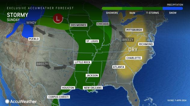
Weather conditions will likely deteriorate in this zone on Sunday as a front advances from the High Plains with showers and thunderstorms.
 |
Those spending time outdoors, especially in tents or campers, should know that even a garden-variety thunderstorm can produce lightning strikes and brief wind gusts with little notice.
The latest indications are that part of this zone will likely remain unsettled with clouds, showers and thunderstorms on eclipse day. The situation could escalate in a few locations to the point that downpours persist and lead to incidents of urban and small-stream flooding.
"Flash flooding is especially a concern on Monday in the zone from western Tennessee to northern Louisiana, including parts of southeastern Arkansas," Travis said.
Campers should be aware of the risk of rapid water surges that can occur along creeks and small rivers, even if downpours occur upstream.
 |
"Enough of a push of dry air may occur to cause clouds to leave in portions of Illinois, Indiana, Ohio, Missouri, northwestern and central Arkansas and western Kentucky in time for the eclipse Monday," AccuWeather Meteorologist Joseph Bauer said.
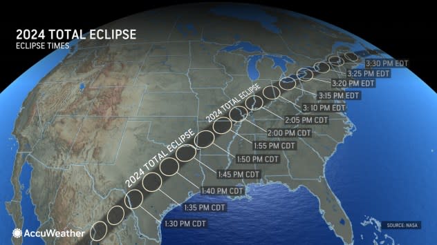
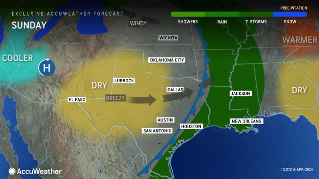
As sunshine holds on over much of the eventual total eclipse path from southwest Texas to Arkansas, it will be very windy across the Great Plains through the rest of the weekend.
 |
"The strong winds can lead to travel disruptions, both in the air and on the ground," Bauer said, adding, "They also can pick up dust, leading to poor air quality and perhaps areas of haze and lowered visibility."
The stiff winds may cause trouble for tents and canopies set up. Vehicles could be sandblasted in extreme cases.
 |
Campers should use caution with open flames as any sparks can quickly set dry brush on fire.
"Warmth more typical of late April will persist across South Texas," AccuWeather Lead Long-Range Meteorologist Paul Pastelok said. "Hats, sunscreen, light-colored clothing and water will be vital for those outside in this area with AccuWeather RealFeel® Temperatures in the 90s F during the afternoons."
 |
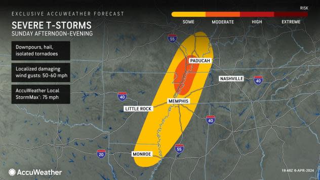
Similar to parts of the Midwest, a push of dry air should be enough to bring the sun out and keep rain away on Sunday for much of the south-central region. Across parts of the Mississippi and Tennessee Valley, however, severe thunderstorms can develop from Sunday afternoon to evening and bring threats of downpours, hail and gusty winds.
On Monday, the atmosphere will begin to moisten. The extent of clouds will begin to increase, but it is possible that the eclipse may still be visible at times.
 |
AccuWeather meteorologists are expecting an increase in the areal coverage of clouds, showers and thunderstorms from late Monday to Tuesday over the southern Plains, so motorists heading home immediately afterward may encounter wet roads and poor visibility on the highway in some cases. Rain may ramp up to the point where localized flooding is possible, and some thunderstorms may be heavy or severe.
"Strong winds, dangerous lightning strikes, hail and perhaps a few tornadoes could threaten those traveling back home the night of April 8 and during the day April 9, especially in Texas north of I-10," Pastelok said. "Storms can also develop in western Oklahoma, western Kansas and northwestern Texas."
 |
"With so many people traveling to unfamiliar areas and camping outdoors or staying in an RV, it's important to take a few minutes to locate your nearest storm shelter. It may be a sturdy restroom building, campground office, a nearby public storm shelter, or even a 24-hour retail store," AccuWeather Director of Forecasting Operations Dan DePodwin said.
"It is extremely important to have multiple ways to get severe weather alerts, especially when they're traveling in unfamiliar areas. If you're staying in a location with limited cell phone signal, ask employees about their weather plan and how they'll notify visitors if a severe storm is approaching. Do not assume that loudspeakers are in place that relay warnings or tornado sirens are within earshot," DePodwin added.
 |
Drenching rain and gusty thunderstorms will become more widespread over the lower part of the Mississippi and Tennessee valleys from Monday night to Thursday. In some cases, secondary roads may become blocked by high water. Downpours will eventually extend across portions of the Ohio Valley and interior Northeast and could renew or aggravate flooding following this past week's deluge.
Want next-level safety, ad-free? Unlock advanced, hyperlocal severe weather alerts when you subscribe to Premium+ on the AccuWeather app. AccuWeather Alerts™ are prompted by our expert meteorologists who monitor and analyze dangerous weather risks 24/7 to keep you and your family safer.


