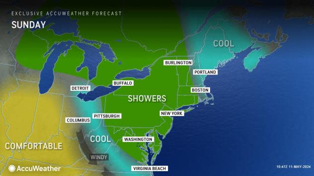
Showers to dampen Mother's Day across Northeast
 |
While Mother's Day weekend will not be a total washout in the Northeast, there will be some places where rain falls through Sunday, AccuWeather meteorologists say.
One such zone will extend from the central Appalachians to the eastern Great Lakes. After one storm moved off the coast at the end of the week, a new storm has arrived from Canada to take its place, but rather than the second storm continuing its quick pace, it will stall over the region.
The storm that moved off the coast Friday was the spearhead of all the severe weather that blasted the central United States on a near-daily basis last week. Invading cool air from the Atlantic helped to dismantle the potential for severe thunderstorms in much of the Northeast. Instead, a zone of clouds, rain and drizzle expanded over the region to end the workweek.
Showers and spotty thunderstorms from the next storm arrived across the Great Lakes region on Friday. night, and expanded across the Ohio Valley and central Appalachians on Saturday. Some of the shower and thunderstorm activity produced brief gusty winds and even small hail into Saturday night, which may seem more typical of March or early April.
In addition, just because one such shower or thundershower occurs does not guarantee that the rest of the day or evening will be dry. Some places may pick up several downpours that can play havoc with outdoor plans such as graduations, weddings and ballgames.
Much of the stretch along Interstate 95 in the mid-Atlantic, as well as most of New England, enjoyed a dry day on Saturday, which will end up being the better of the two weekend days for outdoor plans.
Showers and perhaps rumbles of thunder will linger across parts of the region into Mother's Day.
It is possible that much of Mother's Day afternoon and evening will turn out dry, except for a couple of pop-up showers from the central Appalachians to the mid-Atlantic coast. Clouds and shower activity may persist much of the day in New England.
 |
In terms of temperatures through the end of the weekend, the theme will be cool conditions. Where clouds and showers persist during the daytime, temperatures in New England and the central Appalachians may be no higher than the 50s.
Highs in the mid-Atlantic will range from the mid-50s to the mid-60s. Historical average high temperatures range from near 60 in northern Maine to the mid-70s in southeastern Virginia. Despite the cool conditions, frost is not anticipated due to the extent of cloud cover and moisture in the region.
 |
Looking ahead to the rest of this week in the Northeast, it may be hard to find two days in a row when rain will stay away. Multiple systems from the Central states will roll through regularly, and with no big sweep of dry air between each storm, showers could linger to bridge the gap between each system.
AccuWeather meteorologists urge people with outdoor plans to closely monitor daily and hourly forecasts to help plan for the limited breaks of dry weather that will arise.
Want next-level safety, ad-free? Unlock advanced, hyperlocal severe weather alerts when you subscribe to Premium+ on the AccuWeather app. AccuWeather Alerts™ are prompted by our expert meteorologists who monitor and analyze dangerous weather risks 24/7 to keep you and your family safer.


